
Key Services
Data Processing
High-precision processing of sonar, seismic, and geophysical data for accurate and reliable deliverables. Our workflows ensure quality, consistency and accuracy, as well as full compliance with industry standards.
Sensor Integration
Integrating sensor systems seamlessly for marine survey and monitoring systems. We ensure hardware and software interoperability to capture clean, synchronized data in any
offshore environment.
Edge Computing
Deploying advanced onboard processing to reduce latency and deliver near-real-time results at sea. This approach enables faster data handling directly at the source, improving efficiency and accuracy throughout operations.
Specialist Support Services
Data Analysis
Turning complex marine datasets into clear, actionable insights to support decision-making offshore. Advanced interpretation delivers clarity on seabed conditions, geohazards, and cable routes.
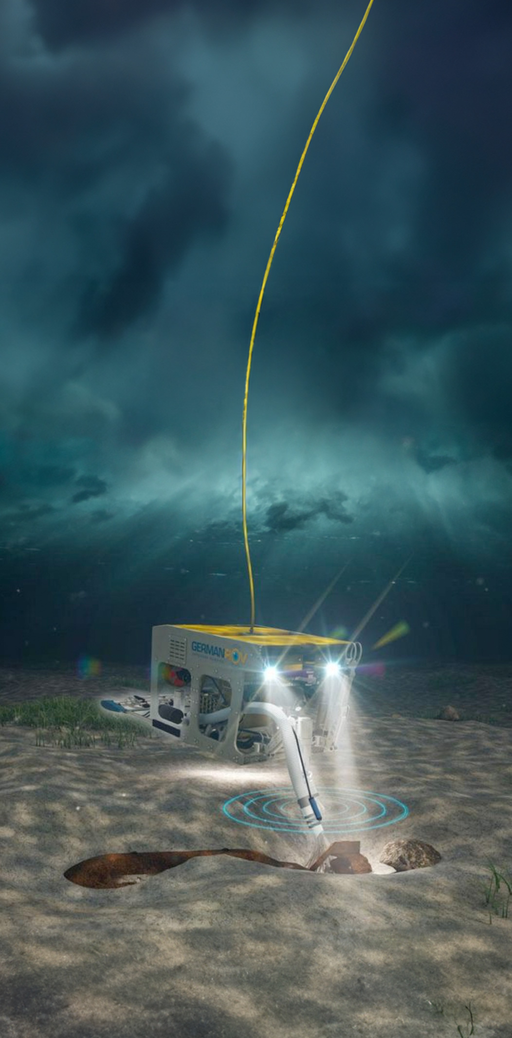
UXO Consultancy
Specialist support in unexploded ordnance (UXO) risk management for offshore development projects. From desk studies to survey interpretation, we help minimise risk and ensure project safety.
Defence Innovation
Applying geophysical expertise to defence research, sensing, and situational awareness challenges. We deliver cutting-edge technical solutions to meet evolving operational demands.
Data Processing
Overview
At League Geophysics, we help clients define the right data requirements from the start, ensuring datasets meet technical and project-specific standards. Acting as consultants, we perform in-field quality checks and data assessments to maintain integrity throughout acquisition and delivery.
Geodata Corrections & Checks
- Fixing positioning and navigation issues
- Reducing sensor and environmental noise
- Verifying data for cable routing and geotechnical planning
- Supporting target list reduction and UXO classification
- Cross-correlating datasets for consistency
- Building and validating 3D velocity models
Geodata Analytics
- Organising, validating, and assessing data quality
- Gap analysis and anomaly classification
- Cable lay planning and UXO surveys
- Geotechnical tie-ins with seismic data
Geodata Processing
- Flexible workflows using industry-standard and custom tools
- Automation of repetitive processes to reduce human error
- Deliverables in any required format, ready for integration
Sensor Integration
Overview
Quality data starts with quality acquisition and at League Geophysics, we support survey operations from planning to final delivery. Our team brings the expertise and reliability needed to ensure smooth integration, efficient operations, and dependable geophysical results.
Survey Support & Oversight
- Assistance with planning, execution, and in-field quality control
- Independent verification of sensor and acquisition performance
Data Processing & Interpretation
- Transforming raw sensor data into actionable insight
- Deliverables optimised for offshore decision-making
Project Delivery Assurance
- End-to-end technical support to meet deadlines and compliance
- Collaboration with survey providers to maintain operational efficiency
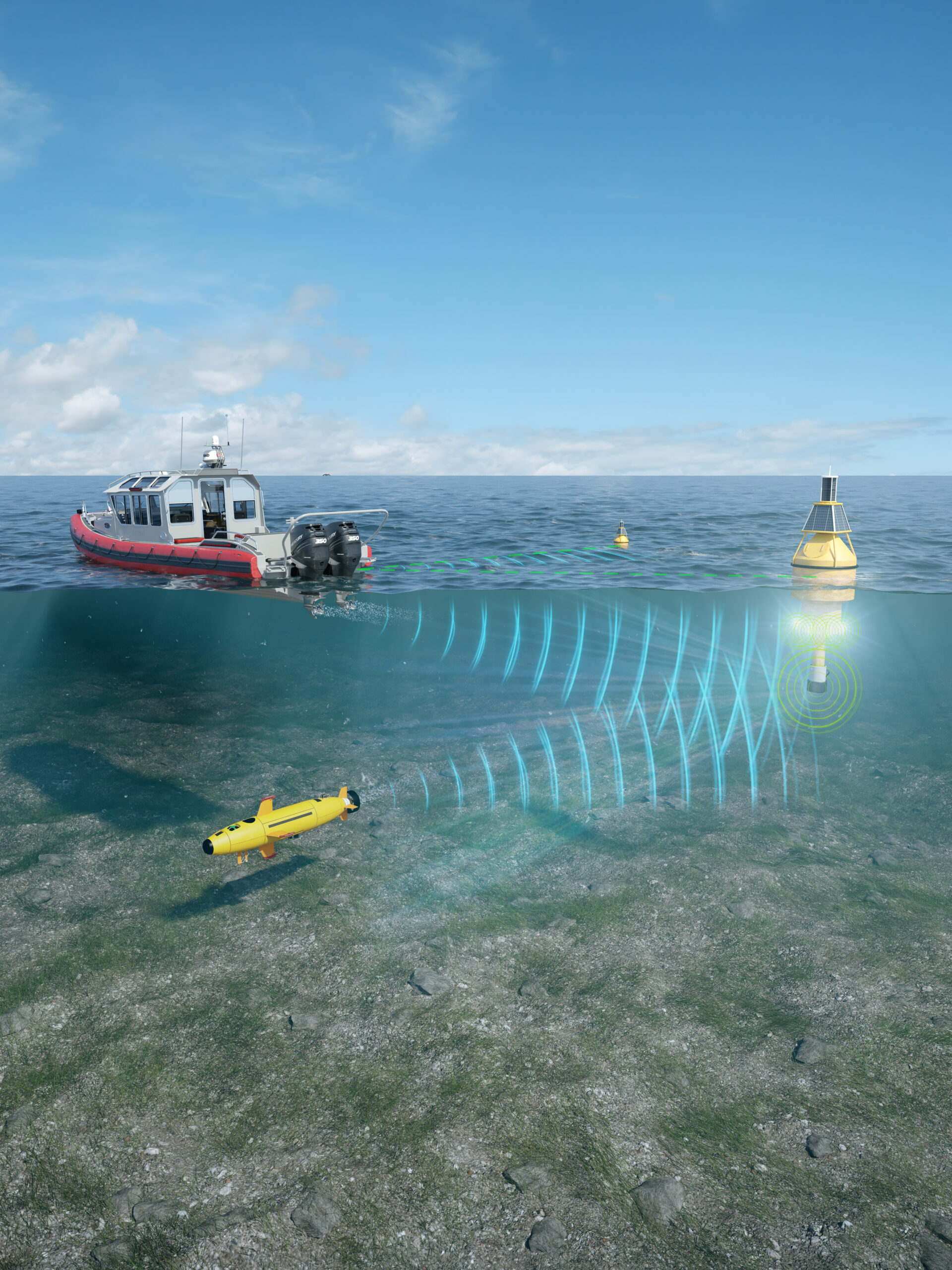
Edge Computing
Overview
By applying advanced onboard processing, League Geophysics moves analytics closer to the point of acquisition. This reduces turnaround time, increases efficiency, and enables survey teams to verify data quality instantly.
Capabilities
- Near real-time data validation and feedback at sea
- Automated noise and error detection during acquisition
- Local processing for reduced transmission time and bandwidth
- Integration with vessel and remote networks for continuous monitoring
- Enhanced situational awareness for safer, more efficient offshore operations
Key Services
Data Processing
High-precision processing of sonar, seismic, and geophysical data for accurate, reliable deliverables. Our workflows ensure quality, consistency, and full compliance with industry standards.
Sensor Integration
Integrating sensor systems seamlessly for marine survey and monitoring systems. We ensure hardware and software interoperability to capture clean, synchronized data in any environment.
Edge Computing
Deploying advanced onboard processing to reduce latency and deliver near-real-time results at sea. Smarter data handling where it matters most, at the source.
Find Out More
At League Geophysics, we help clients define the right data requirements from the start, ensuring datasets meet technical and project-specific standards. Acting as consultants, we perform in-field quality checks and data assessments to maintain integrity throughout acquisition and delivery. Even when data has already been collected, our team can assess and validate its quality to confirm that it meets project objectives.
Geodata Corrections & Checks
Fixing positioning and navigation issues
Reducing sensor and environmental noise
Verifying data for cable routing and geotechnical planning
Supporting target list reduction and UXO classification
Cross-correlating datasets for consistency
Building and validating 3D velocity models
Geodata Analytics
Organising, validating, and assessing data quality
Gap analysis and anomaly classification
Cable lay planning and UXO surveys
Geotechnical tie-ins with seismic data
Geodata Processing
Flexible workflows using industry-standard and custom tools
Automation of repetitive processes to reduce human error
Deliverables in any required format, ready for integration
Find Out More
Quality data starts with quality acquisition and at League Geophysics, we support survey operations from planning to final delivery. Our team brings the expertise and reliability needed to ensure smooth integration, efficient operations, and dependable geophysical results that meet industry and client standards.
Survey Support & Oversight
Assistance with planning, execution, and in-field quality control
Independent verification of sensor and acquisition performance
Data Processing & Interpretation
Transforming raw sensor data into actionable insight
Deliverables optimised for offshore decision-making
Project Delivery Assurance
End-to-end technical support to meet deadlines and compliance
Collaboration with survey providers to maintain operational efficiency
With proven experience and a commitment to innovation, League Geophysics helps survey providers and offshore developers achieve dependable, high-quality results.
Find Out More
By applying advanced onboard processing, League Geophysics moves analytics closer to the point of acquisition. This reduces turnaround time, increases efficiency, and enables survey teams to verify data quality instantly. Edge computing allows faster interpretation, improved situational awareness, and reduced risk across offshore environments.
Capabilities
- Near real-time data validation and feedback at sea
Automated noise and error detection during acquisition
Local processing for reduced transmission time and bandwidth
Integration with vessel and remote networks for continuous monitoring
Enhanced situational awareness for safer, more efficient offshore operations
Specialist Support Services
Data Analysis
Turning complex marine datasets into clear, actionable insights to support confident decision-making offshore. Advanced interpretation delivers clarity on seabed conditions, geohazards, and cable routes.
UXO Consultancy
Specialist support in unexploded ordnance (UXO) risk management for offshore developments. From desk studies to survey interpretation, we help minimise risk and ensure project safety.
Defence Innovation
Applying geophysical expertise to defence research, sensing, and situational awareness challenges. We deliver cutting-edge technical solutions to meet evolving operational demands.
More About Us
At League Geophysics, we bring together decades of offshore experience, advanced technology, and a commitment to quality. Our team delivers precise, dependable geophysical insights that enable safe, efficient subsea and geophysical operations around the world.
Decades of
Expertise
Trusted knowledge built on years of proven offshore success.
Global
Impact
Delivering reliable results across oceans, continents, and industries.
Proven
Reliability
Consistent, accurate data you can depend on every time.
Trusted
Partnerships
Collaborating with clients to achieve long-term success.
Geophysical Expertise
Precision data. Proven performance. Whatever the project, our expertise ensures results you can trust.


- Process Smarter
- Navigate Faster
- Save Vessel Time
Geophysical Services & Offshore Support
League Geophysics combines expertise in data processing, sensor integration, and geophysical innovation to support defence and development projects with precision across offshore operations.